
01From Where Other Things End
How should a visitor choose between China's landscapes?
This layer begins where other things end. The lowland temples end at the mountains held sacred by Buddhists and Daoists. The dynasty sites end at the Great Wall (长城) running through the Gobi and the grassland ruins of Xanadu (元上都). The train ends where the road begins, driving into western Sichuan (四川) from Chengdu (成都). The villages end at the rainforest. Every landscape category on this page carries the same two questions: who drives the last leg, and which months allow entry.
Three tiers of access cost organize this page, ordered by how much effort it takes to stand in front of the landform.
Tier one: step off the train and it is there. The karst peaks around Guilin (桂林), the Hukou Waterfall on the Yellow River, the sandstone peaks of Zhangjiajie (张家界). These have high-speed rail stations within an hour, paved roads to the entrance, and year-round opening. The cost is low, and the main variable is crowding.
Tier two: a full day of driving. The Tibetan Plateau around Ali, the Badain Jaran (巴丹吉林) Desert in Inner Mongolia (内蒙古), the rainforest of Xishuangbanna (西双版纳). These require a flight to a regional hub, then four to eight hours by car, often with a local driver who knows the road. The cost is time and the need to arrange transport in advance.
Tier three: a window that opens once a year. Waterfalls in flood season, wetlands during migration, lakes that freeze in winter alone. The landform is always there, but the version worth seeing exists for a few weeks. The cost is timing, and missing the window means seeing a thin stream, an empty marsh, or open water.
This page is ordered by these three tiers, not by how beautiful a place is. Beauty is subjective; access cost is something a traveler can plan around.
Three objections, answered here.
To begin, if Guilin's karst is right outside the high-speed rail station, does "where other things end" still hold? It holds, with a correction. What ends is the arranged segment, not the transport. The city of Guilin ends at the Li River (漓江). The cable car (索道) ends at the trailhead. The trail ends at the village. This is a hierarchy of layers, not a distance measurement.
Second, the Five Great Mountains (五岳) already appear in the parks page and the hiking page. Is a third appearance repetition? Each page has a different subject. The parks page writes about the entry and the cable car on Mount Tai (泰山). The hiking page writes about the Eighteen Bends path. This page writes about why the Chinese singled out five mountains and what kind of terrain each one is. The three passages do not overlap.
Third, "which months allow entry" sounds like travel advice, not knowledge. The test is whether the information is available elsewhere. The timetable of a single scenic area (景区) is travel advice and belongs to the parks page. The seasonal pattern of an entire landform category is knowledge: waterfalls follow flood seasons, wetlands follow migration, grasslands follow pasture growth, deserts follow temperature swings, snow mountains follow cloud cover. No reference source compiles this table for visitors.
02Four Kinds of Mountain
What kinds of mountains does China have, and which can actually be reached?
China's mountains fall into four categories, and the category determines what kind of visit is possible.
Snow mountains and glaciers. These are the high peaks of the Tibetan Plateau and its edges: Everest, K2, Gongga (贡嘎), Meili (梅里雪山). The defining fact is that many visitors cannot reach the glacier itself. They reach a viewing platform, a cable car (索道) station, or a base camp, and look at the mountain from several kilometers away. The glaciers are retreating. On Yulong Snow Mountain in Yunnan (云南), the Baishui No. 1 Glacier has lost approximately 40 percent of its area over the past four decades, with its terminus rising about 700 meters in elevation. At Hailuogou in Sichuan (四川), the glacier tongue retreated at an average of 12.33 meters per year from 1990 to 2020, accelerating to 66.5 meters per year in 2019 through 2021; the tongue has separated from the upper icefall and lost its dynamic connection. At Urumqi (乌鲁木齐) Glacier No. 1 in Xinjiang (新疆), the area has shrunk by 20 percent since 1959, and the glacier split into east and west branches in 1993. These figures come from peer-reviewed monitoring and the research stations that maintain long-term records.
Sacred mountains. These are the mountains held sacred by Buddhism, Daoism, or Tibetan Bon. The Four Sacred Buddhist Mountains (Wutai (五台山), Emei (峨眉山), Jiuhua (九华山), Putuo (普陀山)) and the Four Sacred Daoist Mountains (Wudang (武当山), Longhu (龙虎山), Qingcheng (青城山), Qiyun (齐云山)) are accessible, with temples, cable cars (索道), and paved paths. The visit is as much about the religious sites as the terrain. In Tibet (西藏), the sacred mountains (Kailash (冈仁波齐), Meili, Amne Machin) require more effort and, for foreign visitors, additional permits.
High mountains. These are peaks above 3,000 meters that are neither permanently snow-capped nor primarily religious. Huangshan (黄山), Taishan (泰山), Huashan (华山), Emei. They have cable cars, hotels near the summit, and marked trails. The visit is a one- or two-day affair.
Scenic mountains. Lower peaks and hill ranges valued for their shape, vegetation, or cultural association. The karst peaks of Guilin (桂林), the red rocks of Danxia, the granite domes of Laoshan. These are often half-day visits from a nearby city.
Why five mountains? The Five Great Mountains (五岳) (Wuyue) are a system codified during the Han dynasty: Taishan in the east, Huashan in the west, Hengshan (Hunan (湖南)) in the south, Hengshan (Shanxi (山西)) in the north, and Songshan (嵩山) in the center. They are chosen by position rather than height or scenery. They were selected because they sit at the cardinal directions of the early Chinese political world, and each became a site of imperial sacrifice. Terrain-wise, they are quite different from each other: Taishan is a block mountain rising from the North China Plain, Huashan is a granite batholith with near-vertical cliffs, Songshan is a folded range. The parks page covers their visits; this page covers why they were chosen.
03Three Plateaus
What are the three plateaus of China and what does altitude change?
China has three major plateaus, and each one changes the visitor's body and schedule in a different way.
The Tibetan Plateau (Qinghai-Xizang Plateau). This is the high one. Much of it sits above 4,000 meters. Lhasa (拉萨) is at 3,650 meters; the towns of Ali are above 4,200 meters. Acute mountain sickness is a real possibility for visitors arriving by air from low elevations. The standard advice is to spend the opening day at rest, avoid alcohol and heavy exercise, and ascend gradually. Visits to the region are arranged through a travel agency, and the rules change. The good months are May through October; winter brings road closures and temperatures well below freezing.
The Yunnan-Guizhou Plateau. This is the middle one, with elevations mostly between 1,000 and 2,000 meters. Altitude sickness is rare. The terrain is characterized by karst, deep river valleys, and a mild climate year-round. Kunming (昆明) is called the "Spring City" because its average temperature stays between 15 and 20 degrees Celsius for much of the year. The cost here is distance instead of altitude: destinations like Yuanyang (元阳), Luoping (罗平), and the stone forest of Shilin (石林) are two to four hours by road from Kunming. The good visiting months are February through April (rapeseed flowers, terraced fields filling with water) and September through November.
The Loess Plateau. This is the dry one, covering parts of Shaanxi (陕西), Shanxi (山西), Gansu (甘肃), and Ningxia (宁夏). Elevations are 800 to 2,000 meters. The terrain is wind-deposited silt (loess) cut by river valleys into a landscape of gullies and tablelands. The climate is continental, with cold winters and hot summers. The good visiting months are May through October. The Loess Plateau is where the Yellow River picks up much of its sediment, and the landscape's connection to Chinese agricultural history is direct: this was the heartland of the Zhou (周), 11th to 3rd century BC, Qin (秦), 3rd century BC, and Han (汉), 2nd century BC to 3rd century AD dynasties.
What altitude means for the schedule. Above 3,000 meters, physical activity slows. A hike that takes two hours at sea level may take three. Sun protection becomes essential because UV intensity increases with elevation. Hydration matters more. For the Tibetan Plateau, many itineraries build in an acclimatization day in Lhasa before going higher. For the Yunnan-Guizhou Plateau, no acclimatization is needed, but the winding roads can cause motion sickness. For the Loess Plateau, the main issue is dust and dry air.
04Three Rocks to Name
What is the difference between karst, Danxia and volcanic landscapes in China?
Karst, Danxia and sandstone peaks, and volcanic landscapes are the three rock formations a visitor can learn to recognize in China. Each has a distinct color, shape, and formation process.
Karst. Karst forms when slightly acidic rainwater dissolves soluble rock, usually limestone. Over millions of years, this creates tower peaks, sinkholes, underground rivers, and caves. A concentrated karst landscape in China is around Guilin (桂林) and Yangshuo (阳朔) in Guangxi (广西), where cone-shaped peaks rise from flat plains and rivers wind between them. Other major karst areas include the stone forest of Shilin (石林) in Yunnan (云南), the karst valleys of Libo (荔波) in Guizhou (贵州), and the cave systems of Chongqing (重庆) and Guizhou. Karst is a landform easily reached by high-speed rail: Guilin Station is on the main line between Guangzhou (广州) and Guiyang, and the peaks are visible from the train window. The good visiting months are April through June and September through November, when the rivers are full and the rice paddies are green or golden.
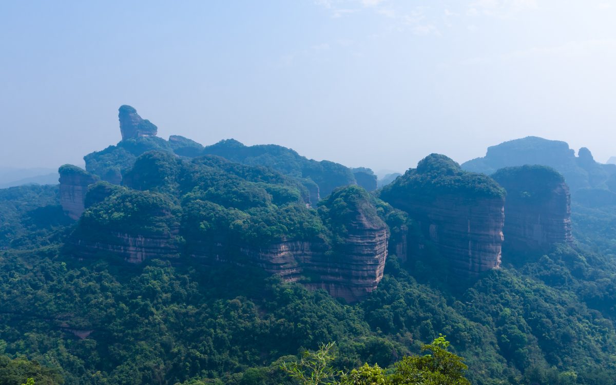
Danxia and sandstone peaks. Danxia forms when red sandstone and conglomerate are uplifted and then eroded by water and frost, creating steep cliffs, flat-topped hills, and deep gorges. The color is the key: rust red, terracotta, sometimes striped with layers of different minerals. In 2010, six Danxia sites were jointly inscribed as a UNESCO World Heritage (世界遗产) series: Taining (泰宁) in Fujian (福建), Langshan (崀山) in Hunan (湖南), Danxiashan in Guangdong (广东), Longhushan (including Guifeng) in Jiangxi (江西), Jianglangshan in Zhejiang, and Chishui (赤水) in Guizhou. A separate but visually related formation is the quartz-sandstone peak forest of Zhangjiajie (张家界) in Hunan, where thousands of narrow pillars rise from a valley floor. Zhangjiajie is not karst: the rock is sandstone, and the pillars formed by water erosion and collapse, not dissolution. The colorful badlands of Zhangye (张掖) in Gansu (甘肃) are often called "Danxia" in travel writing, but they are a different geological formation (multi-colored mudstone and sandstone) and are not part of the 2010 World Heritage series. The good visiting months for Danxia are October through November, when the red rock contrasts with clear autumn skies.
Volcanic landscapes. Volcanic landforms in China are concentrated in three areas: the Changbai Mountains on the border with North Korea (朝鲜), Tengchong (腾冲) in western Yunnan, and the Wudalianchi (五大连池) area in Heilongjiang (黑龙江). Changbai's Tianchi (Heaven Lake) is a crater lake sitting in the caldera of a dormant volcano; it is a very deep alpine lake. Tengchong has a cluster of dormant volcanoes, hot springs, and geothermal fields. Wudalianchi is a volcanic field where eruptions as recently as the 18th century created a landscape of cinder cones and lava flows. Volcanic areas are less visited than karst or Danxia, partly because they are farther from major transport hubs. The good visiting months for Changbai are July through August (when the alpine tundra is in flower and the lake is likely to be visible); for Tengchong, October through April; for Wudalianchi, June through September.
05Lakes and Rivers
Which lakes and rivers in China are worth travelling to, and when?
China's lakes and rivers divide by elevation, and the elevation determines what kind of water body a visitor sees.
Plateau lakes (cuo and haizi). On the Tibetan Plateau, lakes are called cuo in Tibetan. They are often saline or brackish, fed by glacial melt, and ringed by grasslands. Namtso, Yamdrok, and Manasarovar are widely known. At 4,700 meters, Namtso freezes from December through April. The water is a deep blue because of the mineral content and the clarity of the air. Access requires special arrangements and a four-wheel-drive vehicle; the road from Lhasa (拉萨) to Namtso takes four to five hours. In Sichuan (四川) and Yunnan (云南), the Tibetan and Yi (彝族) areas use the term haizi for mountain lakes: Jiuzhaigou (九寨沟)'s multicolored lakes, the alpine lakes of Gongga (贡嘎). These are at 2,000 to 3,500 meters and are accessible by boardwalk (栈道) and shuttle (观光车) bus.
Plain lakes. The middle and lower Yangtze plain has China's large freshwater lakes: Poyang, Dongting, Taihu, Chaohu. These are shallow, productive, and heavily used for fishing and aquaculture (水产养殖). Poyang is a very large freshwater lake, and it undergoes dramatic seasonal change: in flood season (June through September) it covers more than 3,000 square kilometers; in dry season (December through March) it shrinks to a fraction of that, exposing mudflats that become a major wintering ground for migratory birds. The right visiting months depend on what is wanted: summer for the lake itself, winter for the birds.
Great rivers. The Yangtze, Yellow, Pearl, and Lancang (Mekong) rivers are visible from many cities, but the landform worth traveling for is the river in its upper reaches, where it cuts through mountains. The great bend of the Yangtze near Lijiang (丽江), the Tiger Leaping Gorge section, and the Yellow River's Hukou Waterfall are the classic examples. River cruising on the Yangtze (the Three Gorges section) is a transport-based experience; it is covered in the transport context and detailed on the leisure page, so it is not expanded here.
Lakes that freeze. Several lakes in northern and western China freeze solid enough to walk or drive on in winter. Chagan Lake (查干湖) in Jilin (吉林) is known for its winter ice fishing, a tradition that draws visitors from December through February. Qinghai (青海) Lake freezes from January through March. The frozen lakes of the Tibetan Plateau are remote and require local guidance. The ice window is narrow and varies by year; checking conditions before travel is essential.
06Waterfalls and Wetlands
When do Chinese waterfalls have water, and when do the wetlands have birds?
Waterfalls and wetlands share a trait: the month determines everything. A waterfall in dry season is a thin stream; a wetland outside migration season is an empty marsh.
Waterfalls: flood season is the point. China's major waterfalls all have a flood season when the water volume is several times the dry-season average. Huangguoshu (黄果树) in Guizhou (贵州) has a normal flow of roughly 10 to 20 cubic meters per second; in flood season (June through August), it has reached 528 cubic meters per second (measured June 26, 2025) and 482 cubic meters per second (June 23, 2026). At peak flow, the waterfall is a wall of sediment-laden water, and the spray reaches the viewing platforms. Hukou on the Yellow River has two flood seasons: the "peach blossom flood" in March and April, when ice breakup upstream sends 700 to 10,000 cubic meters per second, and the summer flood in July through September, when flow can exceed 1,800 cubic meters per second (measured July 6, 2026). In winter (December through February), Hukou freezes into icefalls and icicles. From May through June, before the summer flood, Hukou can drop to a few hundred cubic meters per second and split into multiple thin streams. Detian Waterfall on the Guangxi-Vietnam border is fullest from June through September. Jiulong Waterfall in Yunnan (云南) peaks in July and August. The dry-season months (November through April) show the rock structure more clearly but far less water.
Wetlands: migration is the point. China's wetlands are liveliest during the spring and autumn migration periods and the wintering season. Zhalong (扎龙) in Heilongjiang (黑龙江) is good from April through May (breeding season for red-crowned cranes) and September through October (autumn migration). Poyang Lake (鄱阳湖) in Jiangxi (江西) is a wintering ground: from November through March, it hosts much of the world's Siberian crane population, plus tens of thousands of other waterfowl. The good months are December and January, early morning. Yancheng in Jiangsu (江苏) is a major wintering ground for red-crowned cranes, with the season running from October through March. Qinghai (青海) Lake has a breeding colony from April through June, when hundreds of thousands of water birds arrive after the lake ice melts. The migration timing shifts by a week or two each year depending on temperature and ice conditions; checking the latest reports from the area's management authority is recommended before planning a trip around a specific week.
Why these are knowledge, not guidebook entries. A single scenic area (景区)'s visiting details are in the parks page. The pattern across an entire category: that waterfalls in China peak in June through August, that the East Asian-Australasian flyway brings cranes to the Yangtze floodplain from November through March, that plateau lakes breed birds from April through June. This pattern is what this page provides.
07Canyons
Which canyons in China can a visitor reach?
Canyons are a landform on this page that must be seen from below. A mountain can be viewed from a summit, a plain from a hill, a lake from a shore. A canyon must be entered, and the entry point determines what is seen.
Tiger Leaping Gorge (Yunnan (云南)). This is a very deep river gorge in China by some measurements, with the Jinsha (金沙) River flowing between Jade Dragon (玉龙雪山) Snow Mountain and Haba (哈巴雪山) Snow Mountain. The upper gorge has a paved viewing path reachable by car from Lijiang (丽江) (about two hours). The high trail, a two-day trek along the canyon's western rim, is one of China's classic hiking routes. The good visiting months are March through May and September through November; summer brings rain and rockfall risk.
Yarlung Tsangpo (雅鲁藏布江) Grand Canyon (Tibet (西藏)). This is a vast canyon, carved by the Yarlung Tsangpo River as it turns south through the Himalayas. Access is limited. The entrance at Pai Town is reachable by road from Nyingchi (about three hours); the inner canyon, including the waterfall area, requires a local guide and special arrangements. The good visiting months are April through June and September through October; July and August bring heavy monsoon (季风) rain and road closures.
Taihang Gorges (Shanxi-Henan-Hebei). The Taihang Mountains have a series of canyons where rivers cut through the eastern edge of the Loess Plateau. The Yuntai (云台山) Mountain gorges in Henan (河南) and the Taihang Grand Canyon in Shanxi (山西) are accessible by car from Zhengzhou (郑州) or Changzhi (two to three hours). These are shorter, narrower canyons with boardwalks and waterfalls. The good visiting months are May through October.
The Nujiang Gorge (Yunnan). The Nujiang (Salween) River cuts a deep valley between the Gaoligong and Biluo snow mountains. The road along the river is one of China's great scenic drives, but it is remote: six to eight hours from Baoshan (保山) or Tengchong (腾冲). The good visiting months are October through April, when the river is clear and the roads are dry.
What makes canyons different. The walls block sunlight, so the bottom of a deep canyon is in shadow for much of the day. Temperatures at the bottom can be 5 to 10 degrees warmer than the rim in winter and cooler in summer. River flow peaks in summer, which means dramatic water but also a high risk of flash floods and rockfall. Many canyons have a paved road or boardwalk (栈道) at the bottom; the ones that do not (the inner Yarlung Tsangpo, sections of the Nujiang) require a guide and careful planning.
08The Dry Half
Where are China's deserts and grasslands, and how are they entered?
The line that divides China's wet east from its dry west is the Hu Huanyong (胡焕庸) Line, drawn in 1935. It runs from Heihe (黑河) in Heilongjiang (黑龙江) to Tengchong (腾冲) in Yunnan (云南). To the west of it lie the deserts and grasslands; to the east, the farmland and cities. The context page on land and climate explains why the line falls where it does; this page describes what it means for a visitor.
Deserts. China's major deserts are the Taklamakan in Xinjiang (新疆) (a very large one, at 337,000 square kilometers), the Badain Jaran (巴丹吉林) in Inner Mongolia (内蒙古) (known for very tall dunes, some over 500 meters), the Gurbantunggut in Xinjiang, and the Tengger (腾格里) and Kubuqi (库布齐) in Inner Mongolia. The Taklamakan's interior is extremely remote; crossing it requires a four-wheel-drive vehicle and a local guide. The desert highways (the Tarim Desert Highway and the newer Hotan-Ruoqiang route) are paved and can be driven in an ordinary car, but stopping in the dunes requires preparation. The Badain Jaran is reachable from Alxa Right Banner (about two hours by road), and tours with local drivers are available. The good visiting months for deserts are April through June and September through October. Summer surface temperatures can exceed 60 degrees Celsius; winter nights drop below -20. The temperature swing between day and night is often 20 degrees or more.
Grasslands. The Hulunbuir (呼伦贝尔) Grassland in Inner Mongolia is a very large one, with peak green from mid-June through early August. The Nalati (那拉提) Grassland in Xinjiang is at 1,800 meters and is green from May through September. The Zoige Grassland on the Sichuan-Gansu border is a high-altitude wetland grassland at 3,500 meters, good from June through August. Grasslands have a short pasture season: before June, the grass is brown; after September, it turns yellow and the herds move down. Visiting outside the green season means seeing a vast, empty landscape, which some travelers prefer, but the grassland as it appears in photographs exists for about ten weeks.
Who can drive in. Many desert and grassland areas are open to self-driving visitors with the right documents; the how-it-works page covers the process. Remote areas have no gas stations for hundreds of kilometers, so carrying spare fuel and water is standard practice for organized tours.
09Forests and Rainforests
Where are China's forests and rainforests?
China has two kinds of forest that a traveler might visit, and they are as different as two landscapes can be.
The boreal forests of the northeast. The Greater Khingan Range in Heilongjiang (黑龙江) and Inner Mongolia (内蒙古) is the southern edge of the Siberian taiga. The trees are larch, birch, and pine. The forest is dense, the winters are long (snow from October through April), and the population is sparse. The good visiting months are September (autumn colors, when the larch turns gold) and June through August (green season, with long daylight hours). The area is reachable by train to Harbin (哈尔滨), then by road or smaller train to Mohe (漠河) or Huzhong. The forest here is not a single scenic area; it is a vast region with logging roads, fire towers, and small towns. Visitors typically base in a town and take day trips into the forest.
The tropical rainforest of Xishuangbanna (西双版纳). In southern Yunnan (云南), bordering Laos and Myanmar, the Xishuangbanna Tropical Botanical Garden and the surrounding protected areas preserve one of China's few remaining tropical rainforests. The trees are evergreen broadleaf, with strangler figs, rattan palms, and orchids. The climate is warm year-round (15 to 30 degrees Celsius), with a rainy season from May through October. The good visiting months are November through April, when rainfall is lower and the forest trails are passable. Xishuangbanna is reachable by air to Jinghong (景洪) (one hour from Kunming (昆明)) or by road (six to eight hours from Kunming). The rainforest here is where the villages end: the Dai (傣族), Hani, and Jinuo villages sit at the forest edge, and beyond them is the protected area.
Other notable forests. The primeval forest of Jiuzhaigou (九寨沟) in Sichuan (四川) is at 2,000 to 3,000 meters and is known for its autumn colors (October). The bamboo forests of southern Sichuan (Shunan Bamboo Sea) are a distinctive monoculture forest. The temperate forests of Wuyishan (武夷山) in Fujian (福建) are a UNESCO biosphere area. Each of these is covered in the parks page for access details; this page notes their forest type and season.
What the two forests have in common. Both are visited well in a specific season. The northeast forest in September, the rainforest in the dry winter months. Both require insect repellent (ticks in the northeast, mosquitoes and leeches in Xishuangbanna). Both are large enough that a single day visit shows a small fraction.
10Coast and Islands
How is the northern Chinese coast different from the southern one?
China's coastline is 18,000 kilometers long, and the northern sea and the southern sea are different experiences.
The northern coast. From Qinhuangdao (秦皇岛) in Hebei (河北) through Dalian (大连) in Liaoning (辽宁) to Qingdao (青岛) in Shandong (山东), the water is cold and the beaches are sandy or pebbly. The swimming season is short: July and August. The rest of the year, the coast is windy and the water is too cold for swimming. Dalian and Qingdao are European-influenced treaty-port cities with coastal architecture. The Changdao Islands off Shandong and the Miaodao Islands are bird migration stopovers in spring and autumn. The good visiting months for the northern coast are May through June and September through October for walking and seafood; July and August for swimming.
The southern coast. From Xiamen (厦门) in Fujian (福建) through Shantou, Shenzhen (深圳), and the Pearl River Delta to Beihai (北海) in Guangxi (广西), the water is warmer and the coastline is rockier, with bays and inlets. The swimming season runs from May through October. Xiamen's Gulangyu (鼓浪屿) Island is a pedestrian historic district. The coastal areas of Guangdong (广东) and Fujian have fishing villages where the fishing industry is still active. The good visiting months are October through April, when the heat and humidity are lower; summer is typhoon season.
Islands. Hainan (海南) is China's tropical island province, with beach resorts at Sanya (三亚) and a less-developed east coast. The swimming season is year-round, though July through September is typhoon season. The Zhoushan (舟山) Archipelago off Zhejiang has Buddhist temples (Putuo (普陀山)) and fishing villages.
Coral reefs and fishing villages. Coral reefs exist in the South China Sea, particularly around Hainan's Wuzhizhou Island. The reefs near Hainan have suffered from bleaching and overfishing. Fishing villages are found along the entire coast, but the ones that still operate as working villages instead of tourist attractions are concentrated in Zhejiang, Fujian, and Guangdong. Visiting a working fishing village requires respect for the fishermen's schedule; a good time is early morning when the boats return.
Skiing and river cruises, noted here because they are often confused with landforms. Skiing is an activity, not a landform; it belongs on the leisure page (and the winter section of Now). Yangtze River cruising is a transport experience; it is covered in the transport context and detailed on the leisure page. Neither is expanded on this page.
11The Cost Table
How far is each Chinese landscape from an airport, and which months are good?
This block is the core of the page. For each landform category, it gives the nearest transport hub, the last leg, and the seasonal window. This is the table a traveler uses to decide whether a destination fits their itinerary.
How to read this table. The "nearest hub" is the closest airport or high-speed rail station. The "last leg" is the time from that hub to the landform itself. The "good months" are when the landform shows its character; visiting outside these months is possible but may show a different version of the same place.
| Landform | Nearest hub | Last leg | Good months |
|---|---|---|---|
| Karst peaks (Guilin) | Guilin high-speed rail / airport | 30 min by car to river | Apr-Jun, Sep-Nov |
| Karst cave (Shilin) | Kunming airport / high-speed rail | 1.5 hr by car | Year-round |
| Danxia (Danxiashan) | Shaoguan high-speed rail | 40 min by car | Oct-Nov |
| Danxia (Zhangye) | Zhangye airport / high-speed rail | 40 min by car | Jun-Sep (colours strongest after rain) |
| Sandstone peaks (Zhangjiajie) | Zhangjiajie airport / high-speed rail | 40 min by car to park | Apr-Jun, Sep-Oct |
| Volcano (Changbai Tianchi) | Changbai airport | 2 hr by car to north gate | Jul-Aug (lake visible) |
| Volcano (Tengchong) | Tengchong airport | 30 min by car | Oct-Apr |
| Volcano (Wudalianchi) | Wudalianchi airport / train | 30 min by car | Jun-Sep |
| Snow mountain (Yulong) | Lijiang airport | 45 min by car to cable car | Nov-May (clearer skies) |
| Glacier (Hailuogou) | Kangding airport / Chengdu | 3.5 hr by car from Chengdu | Oct-Apr (less rain) |
| Sacred mountain (Wutai) | Wutaishan train / Taiyuan airport | 2 hr by car | May-Oct |
| Sacred mountain (Emei) | Emei high-speed rail / Chengdu | 1.5 hr by car | Year-round (snow in winter) |
| High mountain (Huangshan) | Huangshan high-speed rail | 40 min by car to cable car | Apr-May (azaleas), Oct-Nov (autumn) |
| High mountain (Huashan) | Huashan high-speed rail | 15 min by car to gate | Apr-Oct |
| Tibetan Plateau (Lhasa area) | Lhasa airport / train | Within city | May-Oct |
| Tibetan Plateau (Ali) | Ali airport / Lhasa | 2-day drive from Lhasa | May-Sep (roads open) |
| Yunnan-Guizhou (Yuanyang) | Kunming airport | 5 hr by car | Nov-Apr (terraces with water) |
| Loess Plateau (Yan'an) | Yan'an airport / high-speed rail | Within city | May-Oct |
| Plateau lake (Namtso) | Lhasa airport | 4-5 hr by 4WD | May-Oct (frozen Dec-Apr) |
| Plateau lake (Jiuzhaigou) | Jiuzhaigou airport / Chengdu | 1.5 hr by car from airport | Oct (autumn), Jun-Aug (green) |
| Plain lake (Poyang birds) | Nanchang high-speed rail | 2 hr by car to Wucheng | Dec-Jan (migration) |
| Waterfall (Huangguoshu) | Guiyang airport / Anshun train | 1 hr by car | Jun-Aug (flood season) |
| Waterfall (Hukou) | Linfen / Yan'an high-speed rail | 1.5 hr by car | Mar-Apr (ice breakup), Jul-Sep (summer flood) |
| Waterfall (Detian) | Nanning airport | 3 hr by car | Jun-Sep |
| Wetland (Zhalong) | Qiqihar high-speed rail | 1 hr by car | Apr-May (breeding), Sep-Oct (migration) |
| Wetland (Yancheng) | Yancheng high-speed rail | 1 hr by car to coast | Nov-Feb (red-crowned cranes) |
| Wetland (Qinghai Lake birds) | Xining airport / train | 2.5 hr by car | Apr-Jun (breeding) |
| Canyon (Tiger Leaping) | Lijiang airport | 2 hr by car | Mar-May, Sep-Nov |
| Canyon (Yarlung Tsangpo) | Nyingchi airport | 3 hr by car to Pai | Apr-Jun, Sep-Oct |
| Canyon (Yuntai) | Zhengzhou high-speed rail | 2 hr by car | May-Oct |
| Desert (Badain Jaran) | Alxa Right Banner | 2 hr by 4WD to dunes | Apr-Jun, Sep-Oct |
| Desert (Taklamakan highway) | Kuqa / Hotan | Paved highway, no special vehicle | Apr-Jun, Sep-Oct |
| Grassland (Hulunbuir) | Hailar airport | 1-2 hr by car to grassland | Mid-Jun to early Aug (green) |
| Grassland (Nalati) | Nalati airport / Yining | 1 hr by car | May-Sep |
| Forest (Greater Khingan) | Harbin train / Mohe | 3-6 hr by train or car | Sep (autumn), Jun-Aug (green) |
| Rainforest (Xishuangbanna) | Jinghong airport | 1 hr by car to garden | Nov-Apr (dry season) |
| Coast (north, Qingdao) | Qingdao airport / high-speed rail | Within city | May-Jun, Sep-Oct (walking); Jul-Aug (swimming) |
| Coast (south, Xiamen) | Xiamen airport / high-speed rail | Within city | Oct-Apr (cooler) |
| Island (Hainan Sanya) | Sanya airport | Within city | Year-round (avoid Jul-Sep typhoons) |
12How This Page Connects
How does this page relate to the parks, hiking and heritage pages?
- Parks. The parks page covers what happens when a landscape is turned into a scenic area (景区): entry arrangements, cable cars (索道) and shuttle (观光车) buses. This page covers the landform underneath. To judge whether a place is worth visiting, start here; for how to enter, go to the parks page.
- Hiking. The hiking page covers specific trails: who permits them, how long they take, what difficulty. This page covers the terrain the trail passes through. A hike through a karst valley and a hike through a bamboo forest are different experiences; this page explains why.
- Heritage. The heritage page covers human-made objects in the landscape: the Great Wall (长城) in the Gobi, the ruins of Xanadu (元上都) on the grassland, the grottoes cut into sandstone cliffs. This page covers the landscape itself. The Gobi is here; the Han Great Wall running through it is on the heritage page.
- Towns. The towns page covers the streets and settlements near landscapes: the village at the end of the trail, the market town at the edge of the grassland. This page covers the land beyond the town.
- Context: land and climate. That page explains why China's terrain is arranged in three-step terrain (三级阶梯) and why the Hu Huanyong (胡焕庸) Line falls where it does. This page does not repeat that explanation. It assumes the reader knows the terrain is arranged that way, and answers what comes next: which month, which road, which hub.
- How it works. For rules on special areas and driving, see the how-it-works page.
- Coming next: five sub-pages. The second phase of this knowledge domain will expand five categories into dedicated pages: Karst, Coast and Islands, Waterfalls, Wetlands, and Volcanic Landscapes. These were selected because they draw strong visitor interest and have distinctive seasonal patterns. The remaining categories (snow mountains and glaciers, plateaus, deserts and grasslands, forests and rainforests, canyons, lakes and rivers) will be combined into additional pages in the third phase.
- Skiing and river cruises, restated. Skiing is an activity and belongs on the leisure page. Yangtze River cruising is a transport experience and belongs on the leisure page. Both are mentioned here to prevent them from being filed under "snow mountains" or "rivers."