Guangxi · A Waterfall With an International Border in It
Detian Falls (德天瀑布)
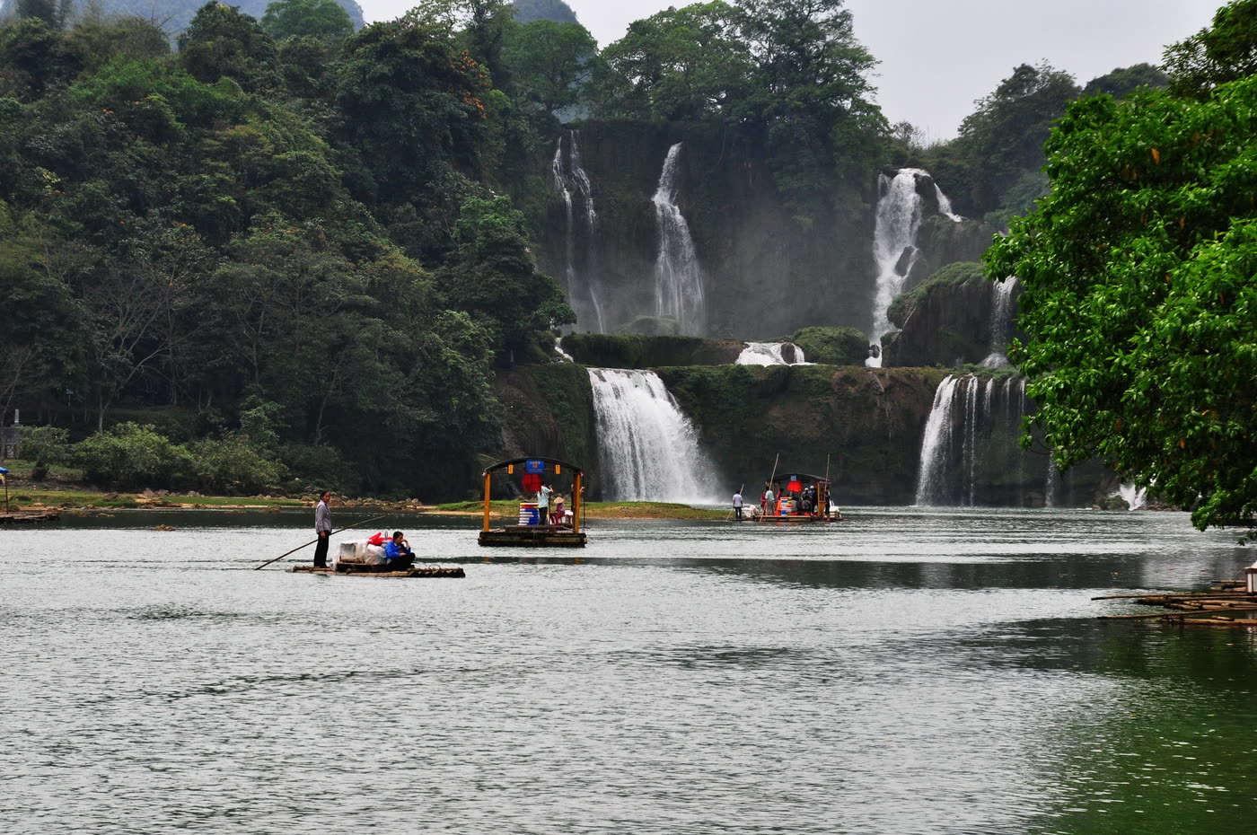
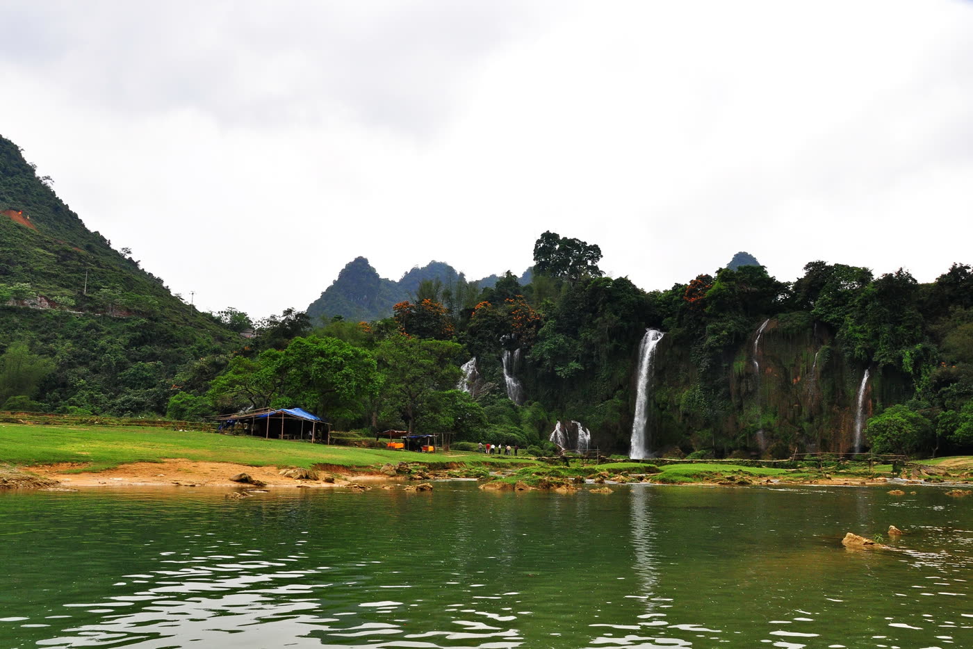
The Guichun river drops over a limestone shelf here, and the river is also the line between China and Vietnam. Rafts work the water in front of the falls, and rice terraces run right up to the foot of them.
Quick Facts
The Short Version
What it is
A wide, terraced waterfall on the Guichun river, shared between China and Vietnam
Its other name
English-language sources, Wikipedia among them, usually call it Ban Gioc-Detian Falls. Ban Gioc is the Vietnamese name for the same falls
Where
Shuolong, in Daxin County, Chongzuo prefecture, on the Guangxi side of the border
Size
The figure usually given is about 200 metres across, dropping in three steps
Getting there
Around three to four hours by road from Nanning. There is no railway to it
On the water
Bamboo rafts run out from the Chinese bank toward the foot of the falls
Documents
This is a border area. Carry the passport; there are checks on the road in
Time needed
Two to three hours on site. Many people come as a long day trip or stay a night nearby
Why Go
One Waterfall, Two Countries, Two Names
1. The border runs through the water
The Guichun river is the international boundary here, so the falls belong to both countries at once. On the Chinese side they are Detian and the scenic area is run from Daxin County; on the Vietnamese side they are Ban Gioc, with a separate viewing area and a separate pass. From either bank visitors can see the other country's visitors on the opposite shore.
That double identity is worth knowing before visitors search for the place, because English-language sources, Wikipedia among them, usually file it under the combined name Ban Gioc-Detian Falls. Ban Gioc is the Vietnamese name. If visitors are cross-checking photographs, daily hours or trip reports against other sites, that is the phrase that will find them, and a good deal of the material written in English describes the Vietnamese approach rather than this one.
A numbered stone boundary marker stands on the Chinese bank below the falls, and the short path down to it is part of the standard visit. The rafts on the river work the same stretch of water from both sides, and small trading goes on between them; one of the boats in the gallery below is a floating stall rather than a passenger raft.
2. It is farmland with a waterfall in it
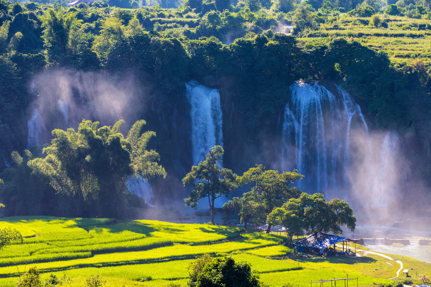
The approach is not through a gate into a landscaped park. Rice terraces come down the slope and stop at the water, buffalo graze on the flats, and the stalls along the bank are sheets of blue tarpaulin on poles. The effect is that the falls read as part of a working valley rather than as an exhibit, which is unusual at a site of this size in China.
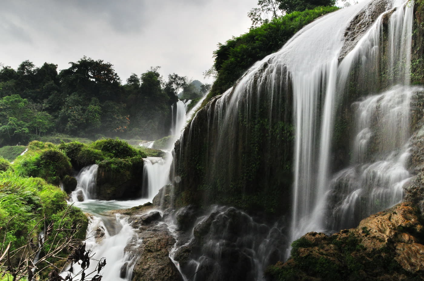
The water itself comes over a limestone shelf in steps rather than in one clean drop. Moss and small plants grow on the lip of every ledge, so the rock is green where it is not wet, and the flow splits into dozens of separate threads before it recombines in the pool. In high water those threads join into broad curtains; in low water they stay separate.
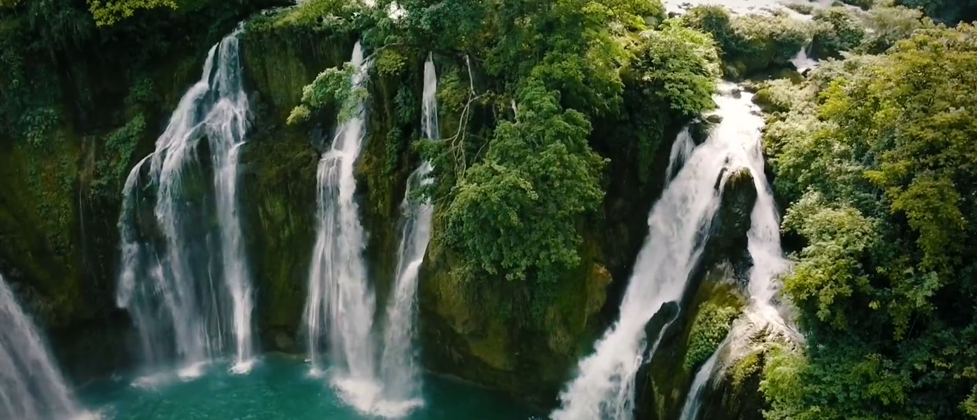
Rafts work the river in front of the falls. The roofed one is a floating stall, not a passenger boat.The paddies stop at the foot of the falls. The blue tarpaulin is a stall, and the path beside it is the way down to the water.From above, in high water. The flow comes over the whole width of the shelf at once rather than through a single channel.The water comes down in steps over a limestone shelf, and the ledges are green with moss wherever the flow does not scour them.The near bank under flat light, with the stalls and the footpath. The flow on this stretch is a set of separate ribbons rather than a single curtain.
The catch. How much water there is changes the visit completely, and the difference is larger here than at many waterfalls. In the wet months the terraces run as continuous curtains and the spray reaches the viewing platforms. In the dry months the same rock carries a set of thin ribbons with a lot of bare grey stone between them. Photographs in brochures are wet-season photographs, and it is a long drive to arrive and find the other version.
Orientation
The Bank, the Marker, and the Water
From the entrance a path runs along the near bank with viewing points at several levels, from the pool at the bottom up to a platform that gives the whole width at once. Walking the full length and back is under an hour at an easy pace, and the upper platform is the one worth the climb.
Two things are separate from that walk and are what many people remember: the short path down to the boundary marker, and the raft, which is bought separately at the jetty and takes about fifteen minutes out toward the foot of the falls and back.
Practical
Things Worth Knowing
Carry the passport
This is a border county and there are checks on the road in. A photograph of the passport page is not enough.
Stay on the visitor side
The boundary runs through the river and along the bank. Follow the marked paths and the raft crew's instructions, and do not cross to the far bank.
Bring cash for the raft and the stalls
The scenic-area pass can be bought online, but the raft and the stalls along the bank generally want cash or a domestic mobile payment.
Pair it with Mingshi
The valley of karst hills and paddies about an hour back toward Nanning is the reason to make this two days rather than one very long one.
Timing
When to Go
Season
The case for
The catch
September to November
The ideal combination on offer: the river is still high after the summer rain and the skies are clearer than they are in July
The opening week of October is the national holiday, and this is a single-road destination
June to August
Peak flow, with the terraces running as full curtains
The wettest and hottest months, with heavy afternoon rain and crowds at their peak
March to May
Green hills, warm weather and far fewer people
Water is still low early in this window. Ask what the flow is doing before committing a day to the drive
December to February
Quiet, mild by Chinese standards, and cheap
The low-water version of the falls: separate ribbons rather than curtains
Context
Why the Water Steps Instead of Dropping
Western Guangxi is karst country, the same limestone that makes the towers around Guilin and Yangshuo. Rivers in this kind of rock behave differently from rivers in granite or sandstone: the limestone dissolves, and the dissolved material comes back out of solution where the water is aerated and turbulent, building up ledges at exactly the places where the river already falls.
The result is a waterfall that grows its own steps. Rather than a single lip retreating upstream, the Guichun has a staircase of deposited shelves, each one furred with moss and plants that trap more material, which is why the profile here is wide and stepped and green instead of a clean vertical drop.
The river is the international boundary, and both countries operate visitor facilities on their own bank. The Chinese side is administered as a scenic area in Daxin County and the Vietnamese side has its own entrance, pass and viewing platforms reached from Cao Bang province.
Nearby
Other Stops on the Same Trip
Valley · 50 km
Mingshi Pastoral (明仕田园)
Paddies, a slow river and karst towers with almost nothing built on them. The usual second half of a Detian trip, and the reason to stay a night.
Half a day. On the road back toward Nanning.
Gorge · 40 km
Tongling Grand Canyon (通灵大峡谷)
A gorge with a tall single-drop waterfall at the head of it, walked on boardwalks and stairs.
Nanning is the base. It is three to four hours away by road, it has the airport and the high-speed rail connections, and there is no train to the falls themselves, so the journey is a car or a tour bus either way.
Done as a day trip it is a long day, much of it spent driving. Done as two days, with a night at Mingshi or in Daxin, it turns into one of the better short trips in the southwest, because the road itself runs through the karst the whole way.
Experiences
What Visitors Can Actually Do Here
On site · 1 hr
The bank path and the upper platform
The viewing points from the pool up to the platform that takes in the full width, and the path down to the boundary marker.
Included in the pass.
On site · 15 min
The bamboo raft
Out onto the river toward the foot of the falls and back, which is the sole way to get the scale of them.
Bought separately at the jetty. Cash.
Guided · 2 days
Detian and the border karst
The falls, Mingshi, and the road between them, with a night in the valley rather than a round trip from Nanning in the dark.
Worth two days, not one. Go between September and November if visitors can, when the river is still high and the sky has cleared, carry the passport for the road checks, and pay for the raft once they are there. If the sole dates visitors have are in late winter, ask what the water is doing at the start, because the dry-season version is a different sight from the one in the photographs.
Travelling to China with 10 or more people? Talk to PreeChina first. A transparent service fee of USD 100 per person for trips of up to 10 days (USD 150 for 11 to 20 days), and no markup on travel components. See how the fee works.
Share the travel dates and interests, and our local team will build the route: Nanning in and out, the falls timed for the light rather than for the coach schedule, a night at Mingshi, and the road back through the karst.